Over the past several months I have been getting some photos of the night sky and other similar types of photos. I decided to take several of the photos and turn it into a post.
All the photos were taken with my Canon 70D camera. Most were taken using a tripod.
In the close up photo of the moon I used a Canon EF 70-200 f/2.8L with a 2x extender.
In the next set of moon photos I was traveling east on I90 just east of North Bend when I saw the moon over the top of the cascades. It was around four in the afternoon and it was still light outside. The moon was noticed by many people several pulled off I90 to take photos. Many of these photos were taken with the stock EF-S 18-135 lens, f/5.6, 20mm zoom.
To experiment with long exposure I went to Western Whitman County where I know about an abandoned farm house and out buildings. It was shortly before midnight and there was very little ambient light. I left the parking lights on my vehicle illuminated on the off-chance a vehicle were to happen down the gravel road at midnight. But the red lights from the vehicle cast a red light into the photos. The photos had an approximately 25 second exposure with settings of ISO800 f/5.6.
I have wanted to do some night sky photos to see the stars. I see so many incredible photos. This is the first time I did it where it turned out okay. I would not say they are the best. But they are okay. I am happy because something other than a black sky appeared. I also tried to get a long exposure photo with the vehicle and the stars in the background. I need to work on that a lot. But again, I am happy it was not all black.
The last photo was taken on Christmas day in Renton, Washington showing a white Christmas.
The moon as seen from outside of Pullman, Washington.
The moon as seen from outside of Pullman, Washington.
A black and white version of the moon as it rises over the Cascade Mountains near North Bend, Washington.
A black and white version of the moon as it rises over the Cascade Mountains near North Bend, Washington.
The moon as it rises over the Cascade Mountains near North Bend, Washington.
The moon as it rises over the Cascade Mountains near North Bend, Washington.
The moon as it rises over the Cascade Mountains near North Bend, Washington.
The moon as it rises over the Cascade Mountains near North Bend, Washington.
An abandoned farm near Lacrosse, Washington. Taken at near midnight using a long exposure.
An abandoned farm near Lacrosse, Washington. Taken at near midnight using a long exposure.
An abandoned farm near Lacrosse, Washington. Taken at near midnight using a long exposure.
An abandoned farm near Lacrosse, Washington. Taken at near midnight using a long exposure.
The Big Dipper with any of its star friends over Western Whitman County
The Big Dipper with any of its star friends over Western Whitman County
On Saturday afternoon I had a chance to ride along with Deputy Stevens from the Whitman County Sheriff’s Office.
We went to the WSU campus to do a couple photos of him with some of the campus in the background. We didn’t make it there until the sun was really setting. This causes some troubles with the backlighting and the lack of lighting for the foreground. I ended up shooting from a different angle so we didn’t get the campus as the backdrop as wanted.
I shot all the photos with my Canon 70D with a EF 70-200mm f/2.8L IS II.
This afternoon there was a mass causality incident drill in which multiple fire and EMS agencies along with the three area hospitals took part.
The scene was an overturned tour bus with approximately 25 patients. Responders came from Fire District 12, Fire District 11, Fire District 4, Albion Fire Department, Pullman Fire Department, and Pullman-Moscow Regional Airport Fire Department. The Whitman County Sheriff’s Office and Lifeflight also participated in this drill.
The Incident Commander was FD12 Captain Eric Gibson.
I had the opportunity to shoot the photographs during the drill.
Firefighter Marv Pillers (an assistant for this drill) is inside the overturned bus with the simulated patients.
Firefighter Marv Pillers (an assistant for this drill) is inside the overturned bus with the simulated patients.
A view of one of the simulated patients inside of the overturned bus.
A view of one of the simulated patients inside of the overturned bus.
The overturned bus prior to the start of the MCI drill.
The overturned bus prior to the start of the MCI drill.
FD12 fire apparatus 12-15 was one of the first arriving units to the scene.
FD12 fire apparatus 12-15 was one of the first arriving units to the scene.
Initial arriving firefighters are overwhelmed with the number of simulated patients.
Initial arriving firefighters are overwhelmed with the number of simulated patients.
Simulated "walking wounded" patients are meandering around the scene upon the arrival of the firefighters.
Simulated "walking wounded" patients are meandering around the scene upon the arrival of the firefighters.
Firefighters start to arrive at the overturned bus.
Firefighters start to arrive at the overturned bus.
Incident Commander, FD12 Captain Eric Gibson, stands beside Rescue 32.
Incident Commander, FD12 Captain Eric Gibson, stands beside Rescue 32.
Firefighters triage the simulated patients with triage tags.
Firefighters triage the simulated patients with triage tags.
A firefighter assists a simulated "walking wounded" patient to safety.
A firefighter assists a simulated "walking wounded" patient to safety.
Firefighters bring medical equipment to deal with all the simulated patients.
Firefighters bring medical equipment to deal with all the simulated patients.
Firefighters bring extrication equipment to cut open the bus.
Firefighters bring extrication equipment to cut open the bus.
Several emergency apparatus can be seen lined up behind the overturned bus.
Several emergency apparatus can be seen lined up behind the overturned bus.
Several emergency apparatus are visible at a MCI drill.
Several emergency apparatus are visible at a MCI drill.
A crew of firefighters arrive on scene of the MCI.
A crew of firefighters arrive on scene of the MCI.
Newly arriving firefighters do a face-to-face to Incident Commander, FD12 Captain Eric Gibson.
Newly arriving firefighters do a face-to-face to Incident Commander, FD12 Captain Eric Gibson.
Two firefighters in the triage area tending to several simulated patients.
Two firefighters in the triage area tending to several simulated patients.
A firefighter has his hands full with multiple simulated patients.
A firefighter has his hands full with multiple simulated patients.
A line of emergency apparatus from multiple agencies are visible during an MCI drill.
A line of emergency apparatus from multiple agencies are visible during an MCI drill.
Firefighter Ian Turner checks on simulated patients inside of a bus.
Firefighter Ian Turner checks on simulated patients inside of a bus.
Firefighters quickly walk a simulated patient on a backboard to a waiting ambulance.
Firefighters quickly walk a simulated patient on a backboard to a waiting ambulance.
Firefighters lift a simulated patient secured to a backboard on to a cot for transport.
Firefighters lift a simulated patient secured to a backboard on to a cot for transport.
Firefighters prepare to load a simulated patient into an ambulance.
Firefighters prepare to load a simulated patient into an ambulance.
Firefighters work prepare to load a simulated patient into an ambulance.
Firefighters work prepare to load a simulated patient into an ambulance.
A simulated patient looks on as another simulated patient is loaded into an ambulance.
A simulated patient looks on as another simulated patient is loaded into an ambulance.
Firefighters starting the process of removing simulated patients from the overturned bus.
Firefighters starting the process of removing simulated patients from the overturned bus.
Firefighters assist a simulated patient out of the overturned bus.
Firefighters assist a simulated patient out of the overturned bus.
Firefighters swarm the scene of the bus accident during an MCI drill.
Firefighters swarm the scene of the bus accident during an MCI drill.
Although there are several ambulances lined up there are more simulated patients than the ambulances on scene can transport to the hospital.
Although there are several ambulances lined up there are more simulated patients than the ambulances on scene can transport to the hospital.
A simulated "walking wounded" patient is tended to by firefighters.
A simulated "walking wounded" patient is tended to by firefighters.
FF Krieger along with other firefighters are outnumbered by simulated patients in the triage area.
FF Krieger along with other firefighters are outnumbered by simulated patients in the triage area.
FF Krieger in the triage area.
FF Krieger in the triage area.
Firefighters wheel a cot to a waiting ambulance.
Firefighters wheel a cot to a waiting ambulance.
A group of firefighters carry a simulated patient on a backboard.
A group of firefighters carry a simulated patient on a backboard.
FF Krieger along with other firefighters are outnumbered by the simulated patients in the triage area.
FF Krieger along with other firefighters are outnumbered by the simulated patients in the triage area.
Incident Commander, FD12 Captain Eric Gibson, along with Pullman Fire Chief Mike Heston and Public Information Officer Glenn Johnson.
Incident Commander, FD12 Captain Eric Gibson, along with Pullman Fire Chief Mike Heston and Public Information Officer Glenn Johnson.
FF Oppegaard and FF Turner making their way into the overturned bus.
FF Oppegaard and FF Turner making their way into the overturned bus.
Firefighters from multiple agencies work together to extricate a simulated patient from an overturned bus.
Firefighters from multiple agencies work together to extricate a simulated patient from an overturned bus.
Firefighters packaging a simulated patient pulled from the overturned bus while firefighters in the distance deal with many more simulated patients in the triage area.
Firefighters packaging a simulated patient pulled from the overturned bus while firefighters in the distance deal with many more simulated patients in the triage area.
Firefighters "package" a simulated patient.
Firefighters "package" a simulated patient.
Lifeflight's helicopter over the scene.
Lifeflight's helicopter over the scene.
Lifeflight's helicopter circling around the scene before landing. (The bird says "Medstar" but it now belongs to Lifeflight after the two companies merged).
Lifeflight's helicopter circling around the scene before landing. (The bird says "Medstar" but it now belongs to Lifeflight after the two companies merged).
Lifeflight's helicopter a foot off the ground during landing.
Lifeflight's helicopter a foot off the ground during landing.
Firefighters tend to simulated patients in the triage area.
Firefighters tend to simulated patients in the triage area.
Media members Evan Ellis and Josh Babcock speak to Incident Commander, FD12 Captain Eric Gibson, while the events are unfolding.
Media members Evan Ellis and Josh Babcock speak to Incident Commander, FD12 Captain Eric Gibson, while the events are unfolding.
Media members Evan Ellis and Josh Babcock speak to Incident Commander, FD12 Captain Eric Gibson, while the events are unfolding.
Media members Evan Ellis and Josh Babcock speak to Incident Commander, FD12 Captain Eric Gibson, while the events are unfolding.
Several patients in the triage area with a number of firefighters helping them.
Several patients in the triage area with a number of firefighters helping them.
FF Marv Pillers looks through the front window of the bus.
FF Marv Pillers looks through the front window of the bus.
A simulated patient is being prepped for placement on Lifeflight's cot.
A simulated patient is being prepped for placement on Lifeflight's cot.
Lifeflight's crew and firefighters work with a large number of simulated patients.
Lifeflight's crew and firefighters work with a large number of simulated patients.
Firefighters working in the triage group discussing patient care.
Firefighters working in the triage group discussing patient care.
FF Oppegaard talking to Incident Commander, FD12 Captain Eric Gibson.
FF Oppegaard talking to Incident Commander, FD12 Captain Eric Gibson.
Several simulated patients are waiting for help during the MCI drill.
Several simulated patients are waiting for help during the MCI drill.
FF Domreis is explaining something to FF Krieger.
FF Domreis is explaining something to FF Krieger.
FF Domries was a member of the extrication team.
FF Domries was a member of the extrication team.
Lt. Parrish listens to FF Krieger.
Lt. Parrish listens to FF Krieger.
Firefighters tend to a simulated patient, placing her on a cot.
Firefighters tend to a simulated patient, placing her on a cot.
A simulated patient is loaded into Lifeflight's bird.
A simulated patient is loaded into Lifeflight's bird.
Incident Commander, FD12 Captain Eric Gibson, reviews information on his incident command board.
Incident Commander, FD12 Captain Eric Gibson, reviews information on his incident command board.
Incident Commander, FD12 Captain Eric Gibson, issues orders via the radio.
Incident Commander, FD12 Captain Eric Gibson, issues orders via the radio.
Firefighters tend to simulated patients in triage.
Firefighters tend to simulated patients in triage.
FF Krieger and FF Domreis.
FF Krieger and FF Domreis.
Firefighters discuss patient care.
Firefighters discuss patient care.
Local Fire and EMS agencies working a bus accident with multiple patients.
Incident Commander, FD12 Captain Eric Gibson.
After all the patients have been extricated from the bus all the remains are the tools and the law enforcement who is helping to block the scene from vehicle traffic.
After all the patients have been extricated from the bus all the remains are the tools and the law enforcement who is helping to block the scene from vehicle traffic.
City of Pullman Mayor Glenn Johnson (who doubles as the Pullman Fire Department's Public Information Officer) is on scene to assist.
City of Pullman Mayor Glenn Johnson (who doubles as the Pullman Fire Department's Public Information Officer) is on scene to assist.
Firefighter Joe Branson in front of Rescue 32.
Firefighter Joe Branson in front of Rescue 32.
A cot is rolled into a triage area with several simulated patients waiting to go to the hospital.
A cot is rolled into a triage area with several simulated patients waiting to go to the hospital.
A view of the overturned bus from the top of Pullman Fire Department's Rescue 32.
A view of the overturned bus from the top of Pullman Fire Department's Rescue 32.
Firefighters load a simulated patient into the back of the ambulance.
Firefighters load a simulated patient into the back of the ambulance.
FD12 Captain Eric Gibson was the Incident Commander for this drill. In this photo Pullman Fire Chief Mike Heston and FD12 Captain Mike Lehmitz are visible in his sunglasses.
FD12 Captain Eric Gibson was the Incident Commander for this drill. In this photo Pullman Fire Chief Mike Heston and FD12 Captain Mike Lehmitz are visible in his sunglasses.
FF Krieger and FF Domreis listening to Lt. Parrish.
FF Krieger and FF Domreis listening to Lt. Parrish
Annie Pillers and Chris Scharer talking over lunch at the debriefing.
Annie Pillers and Chris Scharer talking over lunch at the debriefing.
Randy Miller and David Buckley from Colfax Fire and Rescue in the debriefing.
Randy Miller and David Buckley from Colfax Fire and Rescue in the debriefing.
In a little spot between Pullman, WA and Moscow, ID is a patch of trees in the middle of a wheat field. If you drive around Whitman County it is not unusual to see a small patch of trees in a wheat field. Sometimes there was a house near that spot. But other times I have no idea why they patch of trees exist.
Within this patch of trees was something I would not have expected to find — two abandoned cars. They are parked side-by-side. It looks like they may have been parked there at some point and just never moved again. They don’t look dumped. Even if they were running there would be no way to drive them out of there because of all the tress that would be in the way.
I took the opportunity to take some photographs of the cars.
The trunk of the car is held open by a stick. It is buried up to its frame.
The trunk of the car is held open by a stick. It is buried up to its frame.
An old car sits in the middle of a small patch of woods in the middle of a wheat field between Pullman, WA and Moscow, ID.
An old car sits in the middle of a small patch of woods in the middle of a wheat field between Pullman, WA and Moscow, ID.
The interior of the car is gone. The only thing the remains is the metal.
The interior of the car is gone. The only thing the remains is the metal.
The tire from the car is nearly completely buried.
The tire from the car is nearly completely buried.
A second car is parked next to the first car in the middle of a small patch of woods in the middle of a wheat field between Pullman, WA and Moscow, ID.
A second car is parked next to the first car in the middle of a small patch of woods in the middle of a wheat field between Pullman, WA and Moscow, ID.
A second car is parked next to the first car in the middle of a small patch of woods in the middle of a wheat field between Pullman, WA and Moscow, ID.
A second car is parked next to the first car in the middle of a small patch of woods in the middle of a wheat field between Pullman, WA and Moscow, ID.
On May 1st, 2016 I took a five hour walking photo shoot of a large portion of the central WSU Campus. I have wanted to do this project for a long time and today was a great day to do it. The sun was shining and the sky was blue. I don’t know the exact distance I walked today but it was a lot.
The point of the project is to document that way campus looks at this current time. Over the years I have seen many changes and it is always interesting to look at old photos of the old buildings that are long since gone. The views from various points of campus change with the addition of a new building or the razing of an old building.
There are a couple projects that are about to get underway and I wanted to get the photos before the projects started. The Floyd Multicultural Center will be built between Main Street and Spokane Street along Stadium Way. The area is currently a walking path and a green area. The Public Safety Building with housed the WSU Fire Department (until 2005) and the WSU Police Department (until later this summer). The building will be razed.
I missed out on some opportunities. A portion of KMac was torn down. The front of the old Bookie was torn off. The parking lot and green area south of Owen Science Library already has a new building underway. Troy Hall is under renovation and currently is a shell. I do not have those areas documented before the changes took place. But I finally have my start.
In addition to documenting what campus looked like I hoped to get some neat shots of some of the buildings. In the description of the photos I tried to give some perspective to where I was when the photo was taken. I also included some information about the buildings or areas.
I ended up taking 939 photos during this walking tour of campus. I still have a number of places I never made it to. I was actually running out of time. I plan on making another trip to get more areas that I didn’t make it to this time around.
(this is a long description of the path I took, you can skip over it if you choose)
I have 138 photos in this set. The are in the order I took the photos as I moved around campus. The path I took: Fire Art Parking garage (where I parked). Out to Stadium Way. I turned up Troy Lane and then up College Ave. I went down to Stimson Hall and walked between it and Webster Physical Science. Then in front of Neill Hall and to the back side of Waller Hall. I went up to the parking lot of Stimson and Waller then to Nevada Street. I walked along Waller Hall’s walkway and then out to the grassy area to the south of Waller Hall. I went back to Waller Hall and then across Olympia Ave to Washington Street. I headed west on Washington Street to the parking lot behind the Washington Building (old Pullman Regional Hospital). I walked around to the south side of the Washington Building to the area that I believe to be a portion of the old Finch Memorial Hospital. I walked down the green area behind the hospital to Stadium Way. I went to Spokane Street and then I walked down Stadium Way to Main Street and then back up to Spokane Street. I went on the walking path on the green area between Spokane Street and Main Street (the future home of the Floyd Multicultural Center). I followed the path to the Yellow Parking lot near Washington Street at Spokane Street. I continued north on Spokane Street to Columbia Street and then to College Ave. I continued past Dana Hall towards EE/ME. I crossed the street to the east and up the stairway that leads to Carpenter Hall and the large lawn on the west side of Thompson Hall. I walked north on the walkway on the west side of the grassy area to the footbridge over Spokane Street. I walked across the footbridge. I turned around and went back across the foot bridge towards the lawn on the west side of Thompson Hall. I continued north on the walkway on the west side of the lawn until I was near Honors Hall (the old White Hall). I walked west down the stairs and crossed over Spokane Street. I continued along the walkway west past the back side of the President’s Residence. I continued through the Historical Arch replica down to Albrook Hydraulic Lab and the Oak Street turnaround. I then walked east on the walkway back towards Spokane Street. I crossed the street and up the stairs to the lawn on the west side of Thompson Hall. I continued east on the walkway all the way to Thompson Hall. I walked north around Thompson Hall and up to Veterans Way. I walked south of Veterans Way past the Veterans Memorial, Thompson Hall, Jackson Hall, to Goertzen Hall. I walked on the patio area on the south side of the building all the way to the western most point of the patio. Then went back to the stairway between Goertzen Hall and Morrill Hall. I walked west on the walkway to the west side of Morrill Hall. I went around Morrill Hall back out to Veterans Way. I then headed south a little more on Veterans Way and stopped at Daggy Hall. I went through the old Murrow parking lot where the big satellite dishes used to be housed. I got on the walkway that heads north between Murrow Hall and Jackson Hall. At the end of Jackson Hall is a large grassy area that has Jackson Hall on the south, Stevens Hall to the north, Bryan Hall to the east, and the Veterans Memorial and Veterans Way to the west. I walked through the grassy area west down to the Veterans Memorial. I then went east up the grassy area past the Lowell Elm and Senior Bench. I ended at the Hello Walk on the front side of Bryan Hall. I then took Hello Walk north all the way to Campus Street. I walked up Campus Street to Library Road. At Van Doren Hall I took the walkway that leads east past the front of Van Doren Hall. I continued to the northwest corner Holland Library. I followed the walkway along the west side of Holland Library south to the old main entrance to Holland Library on the southwest corner of the building. I then rounded the corner and walked along the south side of Holland Library. I then walked to the Glenn Terrell Friendship Mall. I walked east on the Terrell Mall past College Hall, Tood Addition, the Compton Union Building (CUB), and to Wilson-Short Hall. I turned south on Troy Land and walked to the plaza of the Smith Center for Undergraduate Education (CUE). Then I went back up Troy Lane to Wilson Road. I walked around the Public Safety Building and back out to Wilson Road. I then walked east on Wilson Road to the French Ad footbridge. I went halfway across the footbridge and then back to Wilson Road. I continued east on Wilson Road to Stadium Way. I then walked south on Stadium Way to the Grimes Way intersection. I then went back into the parking garage which ended my photo shoot for the day.
After completing the 939 photo shoot I had to work to download and go through all the photos. It takes a while to get through all those photos. I chose 138 to include in this photoset. I have 801 photos that didn’t make the cut. I then had to spend a lot of time organizing the information attached to each photo in this set.
In all this project has taken around 25 hours to complete. I hope you enjoy the photos as much as I did taking them. Again the goal of this project is to document the way campus look in May of 2016. I wanted to get photos of buildings as well as sight-lines and overall views of an area.
Smith Center for Undergraduate Education (CUE). Taken from Stadium Way near the driveway to the CUE's parking garage.
Smith Center for Undergraduate Education (CUE). Taken from Stadium Way near the driveway to the CUE's parking garage.
Smith Center for Undergraduate Education (CUE). Taken from Stadium Way near the driveway to the CUE's parking garage.
Smith Center for Undergraduate Education (CUE). Taken from Stadium Way near the driveway to the CUE's parking garage.
Looking north up Troy Lane from near the intersection of Stadium Way and Troy Lane.
Looking north up Troy Lane from near the intersection of Stadium Way and Troy Lane.
Looking up College Ave from the intersection of Troy Lane and College Ave. On the right is the shell of Troy Hall (former home of Ferdinand's) and Fulmer Hall. On the left is Shock Physics.
Looking up College Ave from the intersection of Troy Lane and College Ave. On the right is the shell of Troy Hall (former home of Ferdinand's) and Fulmer Hall. On the left is Shock Physics.
Troy Hall was dedicated in 1926. Troy Hall was once the home to Ferdinand's. The picture shows the only remaining part of Troy Hall is the shell.
Troy Hall was dedicated in 1926. Troy Hall was once the home to Ferdinand's. The picture shows the only remaining part of Troy Hall is the shell.
Another view of Troy Hall. This photo is taken from College Ave looking north. The clear blue sky is visible through the shell of Troy Hall. It was dedicated in 1926. Troy Hall was once the home to Ferdinand's.
Another view of Troy Hall. This photo is taken from College Ave looking north. The clear blue sky is visible through the shell of Troy Hall. It was dedicated in 1926. Troy Hall was once the home to Ferdinand's.
A close up of the entrance to Troy Hall from College Ave. The doorway is several feet off the ground. Troy Hall is undergoing a major renovation. The building was dedicated in 1926. Troy Hall was once the home to Ferdinand's.
A close up of the entrance to Troy Hall from College Ave. The doorway is several feet off the ground. Troy Hall is undergoing a major renovation. The building was dedicated in 1926. Troy Hall was once the home to Ferdinand's.
To the left is a portion of Shock Physics and both Webster Physical Science and Owen Science Library are visible. On the right is the massive Fulmer Hall.
To the left is a portion of Shock Physics and both Webster Physical Science and Owen Science Library are visible. On the right is the massive Fulmer Hall.
Standing near the north east entrance to Webster Physical Science and looking straight up. Due to its location and height it is visible from far outside Pullman.
Standing near the north east entrance to Webster Physical Science and looking straight up. Due to its location and height it is visible from far outside Pullman.
Looking west from the turnaround between Stimson and Waller Halls. A portion of Stimson is visible through the tree on the right. Beyond Stimson is Owen Science Library.
Looking west from the turnaround between Stimson and Waller Halls. A portion of Stimson is visible through the tree on the right. Beyond Stimson is Owen Science Library.
Standing east of the basketball court behind Waller Hall, I am looking east at the green area. In the background is Neill Hall.
Standing east of the basketball court behind Waller Hall, I am looking east at the green area. In the background is Neill Hall.
Looking west at the backside of Waller Hall. At the end of the 2015 school year Waller Hall was closed down as a Men's residence hall. Waller Hall was dedicated in 1935. In 1957 a 4th floor was added to each wing.
Looking west at the backside of Waller Hall. At the end of the 2015 school year Waller Hall was closed down as a Men's residence hall. Waller Hall was dedicated in 1935. In 1957 a 4th floor was added to each wing.
From the turnaround between Stimson and Waller Halls, looking East is the backside of Webster Physical Science (in the distance). Straight ahead is the entrance to Neill Hall. Neill Hall was dedicated in 1957 as a residence hall and converted to the Math building in 1991. To the left is the East wing of Stimson Hall.
From the turnaround between Stimson and Waller Halls, looking East is the backside of Webster Physical Science (in the distance). Straight ahead is the entrance to Neill Hall. Neill Hall was dedicated in 1957 as a residence hall and converted to the Math building in 1991. To the left is the East wing of Stimson Hall.
Looking north from the parking lot is the U-shape area formed between Stimson's East and West wing. There is an old fountain and a basketball court. Stimson Hall was opened in 1922. It is the oldest male residence hall on campus.
Looking north from the parking lot is the U-shape area formed between Stimson's East and West wing. There is an old fountain and a basketball court. Stimson Hall was opened in 1922. It is the oldest male residence hall on campus.
A more close up look at Stimson Hall. Two students are playing basketball on the basketball court that is situated between the West and East wings. Stimson is an all male residence hall and was opened in 1922.
A more close up look at Stimson Hall. Two students are playing basketball on the basketball court that is situated between the West and East wings. Stimson is an all male residence hall and was opened in 1922.
Looking north at the walkway between Stimson Hall on the right and Owen Science Library on the left.
Looking north at the walkway between Stimson Hall on the right and Owen Science Library on the left.
The west side of Waller Hall which faces Nevada Street. Waller Hall was opened in 1935 and at the end of the 2015 school year is no longer being used as a residence hall.
The west side of Waller Hall which faces Nevada Street. Waller Hall was opened in 1935 and at the end of the 2015 school year is no longer being used as a residence hall.
Another view of Waller Hall. This is from the north side of the building looking south. Nevada Street is to the right (on the other side of the temporary fence)
Another view of Waller Hall. This is from the north side of the building looking south. Nevada Street is to the right (on the other side of the temporary fence)
The Education Addition is visible in the background. In the foreground is the work underway for a digital classroom building.
The Education Addition is visible in the background. In the foreground is the work underway for a digital classroom building.
Standing on the walkway in front of Waller Hall the south entrance is to the right and the photo is taken facing north.
Standing on the walkway in front of Waller Hall the south entrance is to the right and the photo is taken facing north.
An old set of steps lead to the walkway and south entrance of Waller Hall. These steps have not been used in decades. An iron railing was installed to keep pedestrians from walking down the steps and I am guessing here, but the building of Nevada Street or its sidewalk at some point rendered these steps unusable. A new staircase was build just to the left of this staircase.
An old set of steps lead to the walkway and south entrance of Waller Hall. These steps have not been used in decades. An iron railing was installed to keep pedestrians from walking down the steps and I am guessing here, but the building of Nevada Street or its sidewalk at some point rendered these steps unusable. A new staircase was build just to the left of this staircase.
In this photo the iron railing is visible which protects pedestrians from using the old staircase. which lead to the walkway and south entrance of Waller Hall. These steps have not been used in decades. I am guessing here, but the building of Nevada Street or its sidewalk at some point rendered these steps unusable. A new staircase was build just to the left of this staircase.
In this photo the iron railing is visible which protects pedestrians from using the old staircase. which lead to the walkway and south entrance of Waller Hall. These steps have not been used in decades. I am guessing here, but the building of Nevada Street or its sidewalk at some point rendered these steps unusable. A new staircase was build just to the left of this staircase.
Looking straight up from the south entrance of Waller Hall.
Looking straight up from the south entrance of Waller Hall.
Near the southwest corner of Waller Hall looking north. Waller Hall is visible on the right. Owen Science Library is partly visible on the right of the photo partly hidden behind the tree. On the right edge of the photo is Cleveland Hall.
Near the southwest corner of Waller Hall looking north. Waller Hall is visible on the right. Owen Science Library is partly visible on the right of the photo partly hidden behind the tree. On the right edge of the photo is Cleveland Hall.
Looking west-northwest from the Waller Hall's walkway is the new construction of the digital classroom along with (from left to right) Education Addition, Cleveland Hall, and Owen Science Library.
Looking west-northwest from the Waller Hall's walkway is the new construction of the digital classroom along with (from left to right) Education Addition, Cleveland Hall, and Owen Science Library.
The open grassy area south of Waller Hall and north of Stadium Way. Through the trees is Kruegel Hall along with the center of KMac. McAllister Hall was razed.
The open grassy area south of Waller Hall and north of Stadium Way. Through the trees is Kruegel Hall along with the center of KMac. McAllister Hall was razed.
Looking at the south face of Waller hall from the grassy area south of Waller Hall.
Looking at the south face of Waller hall from the grassy area south of Waller Hall.
Looking towards the Stadium Way and Nevada Street intersection. On the far left-hand side of the photo is the top of Rogers Hall. The grassy area on the left side of the photo south of Stadium Way is the area where McAllister Hall stood until being razed recently. In the center of the photo is the Stephenson Complex. Stephenson North is the most prominent of the three towers visible in this photo. To the far right is the Washington Building. Until 2004 it was Pullman Memorial Hospital. Before being expanded and named Pullman Memorial Hospital it was Finch Memorial Hospital.
Looking towards the Stadium Way and Nevada Street intersection. On the far left-hand side of the photo is the top of Rogers Hall. The grassy area on the left side of the photo south of Stadium Way is the area where McAllister Hall stood until being razed recently. In the center of the photo is the Stephenson Complex. Stephenson North is the most prominent of the three towers visible in this photo. To the far right is the Washington Building. Until 2004 it was Pullman Memorial Hospital. Before being expanded and named Pullman Memorial Hospital it was Finch Memorial Hospital.
A view of the east side of the Washington Building which was once Pullman Memorial Hospital. To the right of the building is Washington Street and the Education Addition. On the far left is Stephenson North.
A view of the east side of the Washington Building which was once Pullman Memorial Hospital. To the right of the building is Washington Street and the Education Addition. On the far left is Stephenson North.
A closer look at the area that was once McAllister Hall. McAllister Hall was dedicated in 1957 as part of the Kruegel McAllister Residence Hall. Both halls shared a common area. The build was known as KMac for many years. For much of the past two decades KMac was not used as a residence hall and had been "condemned" for years.
A closer look at the area that was once McAllister Hall. McAllister Hall was dedicated in 1957 as part of the Kruegel McAllister Residence Hall. Both halls shared a common area. The build was known as KMac for many years. For much of the past two decades KMac was not used as a residence hall and had been "condemned" for years.
On the northeast corner of the Stadium Way and Nevada Street intersection. Looking to the south with a view of Rogers and Orton Hall peaking over the trees in the center of the photo. Stephenson East is visible on the right side of the photo. The center of KMac is visible on the right side of the photo.
On the northeast corner of the Stadium Way and Nevada Street intersection. Looking to the south with a view of Rogers and Orton Hall peaking over the trees in the center of the photo. Stephenson East is visible on the right side of the photo. The center of KMac is visible on the right side of the photo.
On Washington Street near Nevada Street looking north. The construction site is that of the digital classroom building. The other visible buildings (from left to right) Owen Science Library, Stimson Hall, Waller Hall, and Webster Physical Science.
On Washington Street near Nevada Street looking north. The construction site is that of the digital classroom building. The other visible buildings (from left to right) Owen Science Library, Stimson Hall, Waller Hall, and Webster Physical Science.
The old Emergency Room Ambulance entrance on the east side of the Washington Building (which was Pullman Memorial Hospital until 2004).
The old Emergency Room Ambulance entrance on the east side of the Washington Building (which was Pullman Memorial Hospital until 2004).
On the south side of the Washington Building is this hidden doorway. I believe this is the portion of the Washington Building that was once the original portion of Finch Memorial Hospital which was built in 1928. The sign reads "Medicus Curat Natura Sanat Morbus
Aristotle"
On the south side of the Washington Building is this hidden doorway. I believe this is the portion of the Washington Building that was once the original portion of Finch Memorial Hospital which was built in 1928. The sign reads "Medicus Curat Natura Sanat Morbus
Aristotle"
The backside of the Washington Building as seen from near Stadium Way.
The backside of the Washington Building as seen from near Stadium Way.
The intersection of Stadium Way and Spokane Street. The open grassy area and the walking path in the center of the photo is the site of the new Floyd Multicultural Building. Its construction will being in 2016.
The intersection of Stadium Way and Spokane Street. The open grassy area and the walking path in the center of the photo is the site of the new Floyd Multicultural Building. Its construction will being in 2016.
The Stephenson Complex as seen from the intersection of Stadium Way and Main Street. Once of the new entrance signs is visible on the south-side of Stadium Way.
The Stephenson Complex as seen from the intersection of Stadium Way and Main Street. Once of the new entrance signs is visible on the south-side of Stadium Way.
Looking at the Washington State University sign on the north side of the Stadium Way and Main Street intersection. The area in the center of the photo is the future home of the Floyd multicultural Center.
Looking at the Washington State University sign on the north side of the Stadium Way and Main Street intersection. The area in the center of the photo is the future home of the Floyd multicultural Center.
"Washington State University" in large lettering on a sign which was constructed in 2015.
"Washington State University" in large lettering on a sign which was constructed in 2015.
"Washington State University" in large lettering on a sign which was constructed in 2015.
"Washington State University" in large lettering on a sign which was constructed in 2015.
The "Washington State University" welcome signs are visible on both sides of the Stadium Way and Main Street intersection. In the background is the Stephenson Complex which includes three towers (North, South, and East) along with a center complex. At one time there was a dining center, computer lab, convenience store, study lounges, recreation areas, and more. The Complex can hold around 900 students. The North and South towers were completed in 1966. The East tower was completed in 1969.
The "Washington State University" welcome signs are visible on both sides of the Stadium Way and Main Street intersection. In the background is the Stephenson Complex which includes three towers (North, South, and East) along with a center complex. At one time there was a dining center, computer lab, convenience store, study lounges, recreation areas, and more. The Complex can hold around 900 students. The North and South towers were completed in 1966. The East tower was completed in 1969.
The "Washington State University" welcome signs is visible the south side of the Stadium Way and Main Street intersection. In the background is the Stephenson Complex which includes three towers (North, South, and East) along with a center complex. At one time there was a dining center, computer lab, convenience store, study lounges, recreation areas, and more. The Complex can hold around 900 students. The North and South towers were completed in 1966. The East tower was completed in 1969.
The "Washington State University" welcome signs is visible the south side of the Stadium Way and Main Street intersection. In the background is the Stephenson Complex which includes three towers (North, South, and East) along with a center complex. At one time there was a dining center, computer lab, convenience store, study lounges, recreation areas, and more. The Complex can hold around 900 students. The North and South towers were completed in 1966. The East tower was completed in 1969.
A straight-on view of the "Washington State University" sign on the north side of the Stadium Way and Main Street intersection.
A straight-on view of the "Washington State University" sign on the north side of the Stadium Way and Main Street intersection.
The green area and walking path on the north side of Stadium Way situated between Main Street and Spokane Street. This area is the future home of the Floyd Multicultural Building.
The green area and walking path on the north side of Stadium Way situated between Main Street and Spokane Street. This area is the future home of the Floyd Multicultural Building.
On the green area and walkway that is north of Stadium way. It is situated between Main Street and Spokane Street. It is the future home of the Floyd Multicultural Center. Looking south towards the Stephenson Complex.
On the green area and walkway that is north of Stadium way. It is situated between Main Street and Spokane Street. It is the future home of the Floyd Multicultural Center. Looking south towards the Stephenson Complex.
A wider view of the green space and walking path which is north of Stadium Way situated between Main Street and Spokane Street. The North and East tower of the Stephenson Complex along with Rogers Hall are visible in the background.
A wider view of the green space and walking path which is north of Stadium Way situated between Main Street and Spokane Street. The North and East tower of the Stephenson Complex along with Rogers Hall are visible in the background.
At the intersection of Spokane Street and Washington Street. Spokane Street is to the left and Washington Street is straight ahead. At the other end of Washington Street is Nevada Street along with the Washington Building, Waller Hall, and the construction site of the new digital classroom building. Along Spokane Street are some of the engineering buildings such as Sloan, Dana, and EE/ME.
At the intersection of Spokane Street and Washington Street. Spokane Street is to the left and Washington Street is straight ahead. At the other end of Washington Street is Nevada Street along with the Washington Building, Waller Hall, and the construction site of the new digital classroom building. Along Spokane Street are some of the engineering buildings such as Sloan, Dana, and EE/ME.
Looking south down Spokane Street towards Stadium Way. In the background is the East and South towers of the Stephenson Complex. The area where the Floyd Multicultural Center will be built in 2016 is nothing but grass and trees in this photo.
Looking south down Spokane Street towards Stadium Way. In the background is the East and South towers of the Stephenson Complex. The area where the Floyd Multicultural Center will be built in 2016 is nothing but grass and trees in this photo.
Looking west towards the city of Pullman from Spokane Street. The gravel parking lots are nearly empty.
Looking west towards the city of Pullman from Spokane Street. The gravel parking lots are nearly empty.
Looking north up Spokane Street at the Spokane Street and Columbia Street intersection.
Looking north up Spokane Street at the Spokane Street and Columbia Street intersection.
Looking down Columbia Street. At one time, after WWII, I understand there was a fair amount of housing in this area.
Looking down Columbia Street. At one time, after WWII, I understand there was a fair amount of housing in this area.
Looking east on Columbia Street from Spokane Street. A little bit of the deep red bricks from the Education Addition are visible.
Looking east on Columbia Street from Spokane Street. A little bit of the deep red bricks from the Education Addition are visible.
Carpenter Hall is visible on the left and Daggy Hall is on the right. As seen from Spokane Street near College Ave. Carpenter Hall is a twin to Wilson-Short Hall. Carpenter Hall was dedicated in 1915. The building was not completed until 1926 because of WWI. Daggy Hall was dedicated in 1973. Daggy Hall has a theatre which is used for many live performances.
Carpenter Hall is visible on the left and Daggy Hall is on the right. As seen from Spokane Street near College Ave. Carpenter Hall is a twin to Wilson-Short Hall. Carpenter Hall was dedicated in 1915. The building was not completed until 1926 because of WWI. Daggy Hall was dedicated in 1973. Daggy Hall has a theatre which is used for many live performances.
The Engineering Teaching Research Lab (ETRL) is on the right side of the photo. Dana Hall is in the center of the photo taken from the College Ave and Spokane Street intersection. The ETRL was completed in 1997 and Dana Hall was completed in 1948.
The Engineering Teaching Research Lab (ETRL) is on the right side of the photo. Dana Hall is in the center of the photo taken from the College Ave and Spokane Street intersection. The ETRL was completed in 1997 and Dana Hall was completed in 1948.
Looking west on College Ave from the Spokane Street intersection. The Engineering Teaching Research Lab (ETRL) is visible on the right side of the photo. This was once the main entrance to campus.
Looking west on College Ave from the Spokane Street intersection. The Engineering Teaching Research Lab (ETRL) is visible on the right side of the photo. This was once the main entrance to campus.
The east entrance into Dana Hall. Dana hall was completed in 1948. According to the WSU master plan this building will be razed and in its place will be a green space.
The east entrance into Dana Hall. Dana hall was completed in 1948. According to the WSU master plan this building will be razed and in its place will be a green space.
Carpenter Hall was completed in 1926. The building is a twin to Wilson-Short Hall. An interesting note about this building is that its main entrance was supposed to be on the second floor, just like Wilson-Short Hall. However it was never made into an entrance. Behind the trees at the central part of the building is the very top of what would have been the second floor entrance.
Carpenter Hall was completed in 1926. The building is a twin to Wilson-Short Hall. An interesting note about this building is that its main entrance was supposed to be on the second floor, just like Wilson-Short Hall. However it was never made into an entrance. Behind the trees at the central part of the building is the very top of what would have been the second floor entrance.
The north entrance of Dana Hall. Dana hall was completed in 1948. According to the WSU master plan this building will be razed and in its place will be a green space.
The north entrance of Dana Hall. Dana hall was completed in 1948. According to the WSU master plan this building will be razed and in its place will be a green space.
The northwest corner of Carpenter Hall. Although not visible in this photo the entrance as designed is visible on the second floor of the building. The lay of the land around Carpenter Hall made it impracticable to use the second floor entrance.
The northwest corner of Carpenter Hall. Although not visible in this photo the entrance as designed is visible on the second floor of the building. The lay of the land around Carpenter Hall made it impracticable to use the second floor entrance.
A large grassy field south of Thompson Hall. The grassy field is used by students for relaxation, studying, playing Frisbee, and being with friends.
A large grassy field south of Thompson Hall. The grassy field is used by students for relaxation, studying, playing Frisbee, and being with friends.
A foot bridge over Spokane Street allows students make entry into EE/ME.
A foot bridge over Spokane Street allows students make entry into EE/ME.
The north side of Carpenter Hall as seen from the large grassy area to the west of Thompson Hall. In this photo a student is playing a violin as part of a photo shoot.
The north side of Carpenter Hall as seen from the large grassy area to the west of Thompson Hall. In this photo a student is playing a violin as part of a photo shoot.
Looking south from the foot bridge over Spokane Street.
Looking south from the foot bridge over Spokane Street.
Looking north from the foot bridge over Spokane Street.
Looking north from the foot bridge over Spokane Street.
Looking east from the foot bridge over Spokane Street. The castle-looking Thompson Hall is visible.
Looking east from the foot bridge over Spokane Street. The castle-looking Thompson Hall is visible.
Using a zoom lens to get a closer look at Thompson Hall from the footbridge over Spokane Street. Thompson Hall was completed in 1894. It is the oldest building in existence on WSU's campus. It was once the home of the administration.
Using a zoom lens to get a closer look at Thompson Hall from the footbridge over Spokane Street. Thompson Hall was completed in 1894. It is the oldest building in existence on WSU's campus. It was once the home of the administration.
Peaking over the top of Goertzen Hall is the clock from Bryan Tower.
Peaking over the top of Goertzen Hall is the clock from Bryan Tower.
A view of EE/ME on the west side of Spokane Street.
A view of EE/ME on the west side of Spokane Street.
Looking west from Spokane Street along the pathway that leads to Albrook Hydraulic Lab and the Oak Street cul-de-sac.
Looking west from Spokane Street along the pathway that leads to Albrook Hydraulic Lab and the Oak Street cul-de-sac.
A nice grassy area with some mature bushes that help to hide the backyard of the President's Mansion.
A nice grassy area with some mature bushes that help to hide the backyard of the President's Mansion.
The backside of the historical arch. The arch is a smaller scale replica of the arch that once greeted people to the WSU campus.
The backside of the historical arch. The arch is a smaller scale replica of the arch that once greeted people to the WSU campus.
Looking at the front of the Historical arch that is a smaller scale replica of the original arch that welcomed people WSU. This arch is near the south end of Oak Street near Albrook Hydraulic Labs.
Looking at the front of the Historical arch that is a smaller scale replica of the original arch that welcomed people WSU. This arch is near the south end of Oak Street near Albrook Hydraulic Labs.
In the foreground is a small corner of the Albrook Hydraulic Lab. In the distance is the Greystone Church. It was nearly razed due to neglect but was saved by a developer who turned it into housing.
In the foreground is a small corner of the Albrook Hydraulic Lab. In the distance is the Greystone Church. It was nearly razed due to neglect but was saved by a developer who turned it into housing.
The Oak Street cul-de-sac as seen from Albrook Hydraulic Lab. Oak Street is off campus.
The Oak Street cul-de-sac as seen from Albrook Hydraulic Lab. Oak Street is off campus.
Looking through the Historical arch up a long path that goes over Spokane Street and continues up to Thompson hall. Entrance doors to Thompson Hall are visible in this photo.
Looking through the Historical arch up a long path that goes over Spokane Street and continues up to Thompson hall. Entrance doors to Thompson Hall are visible in this photo.
Honors Hall is a residence hall. It was once known as White Hall before it was converted into a residence hall. Build in 1927 it was an academic building until 2000 when it was remodeled for residential living. The lowest portion of the building is pure white and the entrance used to lead into a computer lab. Before the construction in 2000 to turn it into a residential building that whole area was totally underground.
Honors Hall is a residence hall. It was once known as White Hall before it was converted into a residence hall. Build in 1927 it was an academic building until 2000 when it was remodeled for residential living. The lowest portion of the building is pure white and the entrance used to lead into a computer lab. Before the construction in 2000 to turn it into a residential building that whole area was totally underground.
Looking at the entrance on the west side of Thompson Hall from ground level along the pathway that leads to the Historical arch.
Looking at the entrance on the west side of Thompson Hall from ground level along the pathway that leads to the Historical arch.
McCroskey Hall was built in 1920 and is the second oldest residence hall in existence on campus. This is the south side of the building.
McCroskey Hall was built in 1920 and is the second oldest residence hall in existence on campus. This is the south side of the building.
Looking up the face of Thompson Hall. It was built in 1894 and is the oldest building on campus that still exists. At one time it was the administration building and used for many other purposes over its lifetime.
Looking up the face of Thompson Hall. It was built in 1894 and is the oldest building on campus that still exists. At one time it was the administration building and used for many other purposes over its lifetime.
The sign over the top of the west entrance doors of Thompson Hall reads "Administration Building". Thompson Hall was built in 1894 and is the oldest building on campus that still exists.
The sign over the top of the west entrance doors of Thompson Hall reads "Administration Building". Thompson Hall was built in 1894 and is the oldest building on campus that still exists.
Another view of the west entrance of Thompson Hall. It has a sign over the top of the west entrance doors of Thompson Hall which reads "Administration Building". Thompson Hall was built in 1894 and is the oldest building on campus that still exists.
Another view of the west entrance of Thompson Hall. It has a sign over the top of the west entrance doors of Thompson Hall which reads "Administration Building". Thompson Hall was built in 1894 and is the oldest building on campus that still exists.
Morrill Hall is named after Senator Justin Morrill who introduced legislation for land grand institutions. This building was dedicated in 1903.
Morrill Hall is named after Senator Justin Morrill who introduced legislation for land grand institutions. This building was dedicated in 1903.
Goertzen Hall is visible in the foreground of this photo. In the background is Thompson Hall. The photo is looking north from Veterans Way. The building was completed in 2003 and was originally known as the Communication Annex. In 2013 it was renamed Goertzen Hall after Kathi Goertzen who was a WSU alum and a KOMO (Seattle, WA) TV News Anchor.
Goertzen Hall is visible in the foreground of this photo. In the background is Thompson Hall. The photo is looking north from Veterans Way. The building was completed in 2003 and was originally known as the Communication Annex. In 2013 it was renamed Goertzen Hall after Kathi Goertzen who was a WSU alum and a KOMO (Seattle, WA) TV News Anchor.
A view of the entrance into Morrill Hall surrounded by basalt stones. Morrill Hall was completed in 1903.
A view of the entrance into Morrill Hall surrounded by basalt stones. Morrill Hall was completed in 1903.
Looking across Veterans Way from Morrill Hall is Eastlick and Heald Halls. Eastlick is brick. Health Hall was built in the 60's when several of the buildings on campus were built without a brick exterior. Not a very pleasing sight.
Looking across Veterans Way from Morrill Hall is Eastlick and Heald Halls. Eastlick is brick. Health Hall was built in the 60's when several of the buildings on campus were built without a brick exterior. Not a very pleasing sight.
The Math Learning Annex is situated south of Daggy Hall. It was built in 1908 and was originally the hydraulics lab. According to a WSU Historical building website "The cupola served as an extension roof and cover for the stand pipe 45 feet high which regulates the flow of water in the hydraulics laboratory."
The Math Learning Annex is situated south of Daggy Hall. It was built in 1908 and was originally the hydraulics lab. According to a WSU Historical building website "The cupola served as an extension roof and cover for the stand pipe 45 feet high which regulates the flow of water in the hydraulics laboratory."
Eastlick Hall was built in 1977. The plaza has a metal sculpture, which according to my art professor, was designed to visually fit into the square inlet on the face of the building. This photo was taken to demonstrate how the art was supposed to tie into the building.
Eastlick Hall was built in 1977. The plaza has a metal sculpture, which according to my art professor, was designed to visually fit into the square inlet on the face of the building. This photo was taken to demonstrate how the art was supposed to tie into the building.
The front of Murrow Hall is visible on the left. Eastlick Hall is visible in the distance. Murrow was built in 1899. The entrance to the building is visible with the concrete colored archway. The entrance to the building is now located under the footbridge which connects Murrow Hall with Jackson Hall. The original entrance (pictured) has been converted into windows.
The front of Murrow Hall is visible on the left. Eastlick Hall is visible in the distance. Murrow was built in 1899. The entrance to the building is visible with the concrete colored archway. The entrance to the building is now located under the footbridge which connects Murrow Hall with Jackson Hall. The original entrance (pictured) has been converted into windows.
A view to the south and east from the Veterans Memorial. From left to right in the photo: Jackson Hall, Veterans Way, Morrill Hall, Goertzen Hall, and Thompson Hall.
A view to the south and east from the Veterans Memorial. From left to right in the photo: Jackson Hall, Veterans Way, Morrill Hall, Goertzen Hall, and Thompson Hall.
In the foreground is an Elm Tree planted by Dr. and Mrs. E. A. Bryan in 1893. The tree is known as the Lowell Elm because the seedling was transplanted from Elmwood the estate of James Russell Lowell. According to a 2003 press release by WSU the Lowell Elm is nearing the end of its lifespan but seedlings from the tree has been planted around campus.
In the middle of the photo is the Senior Bench that was donated by the senior class of 1910. The bench is just west of Hello Walk near Bryan Hall.
A view of the front of Bryan Hall. It was built in 1909 and has been a fixture of Pullman's skyline for more than a century. The clock tower rises 113 feet in elevation and the building It sits near one of the highest points of College Hill which helps make it such a prominent sight. At night the face of the clock turns red. The chimes of the clock can be heard around campus on the hour. It has been known to have the five o'clock bells when there is music that comes from the tower.
A view of the front of Bryan Hall. It was built in 1909 and has been a fixture of Pullman's skyline for more than a century. The clock tower rises 113 feet in elevation and the building It sits near one of the highest points of College Hill which helps make it such a prominent sight. At night the face of the clock turns red. The chimes of the clock can be heard around campus on the hour. It has been known to have the five o'clock bells when there is music that comes from the tower.
This sculpture sites along Hello Walk just north of Bryan Hall. It has the Greek letters Sigma Tau on the side. It is hard to say exactly what it was and there isn't any information about it that I could find. It appears to be an old drinking fountain.
This sculpture sites along Hello Walk just north of Bryan Hall. It has the Greek letters Sigma Tau on the side. It is hard to say exactly what it was and there isn't any information about it that I could find. It appears to be an old drinking fountain.
Looking north from where the sidewalk ends (Hello Walk, that is). The old Bookie building and a portion of Kimbrough Hall is visible. The Bookie was built in 1954 and served as a bookstore until 2008 when it moved into the CUB. The front of the building which served as a covered walkway. It was made of bricks and gave a new look to the building has been torn off the building in preparation of the building to be repurposed as another student center. The covered walkway was added to the store during a remodel in the late 90's, if I recall correctly.
Looking north from where the sidewalk ends (Hello Walk, that is). The old Bookie building and a portion of Kimbrough Hall is visible. The Bookie was built in 1954 and served as a bookstore until 2008 when it moved into the CUB. The front of the building which served as a covered walkway. It was made of bricks and gave a new look to the building has been torn off the building in preparation of the building to be repurposed as another student center. The covered walkway was added to the store during a remodel in the late 90's, if I recall correctly.
Kimbrough Hall was built in 1965 and is the home of the music department and the Cougar Marching Band. The building sits between the old Bookie and Van Doren Hall along Library Road.
Kimbrough Hall was built in 1965 and is the home of the music department and the Cougar Marching Band. The building sits between the old Bookie and Van Doren Hall along Library Road.
Looking east and south from near the north end of Hello Walk is a view of Kimbrough, Van Doren, Holland Library, and a small corner of Avery Hall (left to right).
Looking east and south from near the north end of Hello Walk is a view of Kimbrough, Van Doren, Holland Library, and a small corner of Avery Hall (left to right).
Looking south from the west side of Kimbrough hall Van Doren Hall, Holland Library, College Hall, Bryan Hall, and Avery Hall are visible from left to right.
Looking south from the west side of Kimbrough hall Van Doren Hall, Holland Library, College Hall, Bryan Hall, and Avery Hall are visible from left to right.
The west side of Van Doren Hall and Halland Library as seen from an old turnaround on the road that no longer exists.
The west side of Van Doren Hall and Halland Library as seen from an old turnaround on the road that no longer exists.
Library Road used to be an actual road with raised side walks. A number of years ago the road was resurfaced to turn it into a walking area. Emergency vehicles and service vehicles are still able to drive along the walking area but usually have to do so at a slow pace. In this photo the backside of Bryan Hall and the front side of Holland Library are seen facing Library Road.
Library Road used to be an actual road with raised side walks. A number of years ago the road was resurfaced to turn it into a walking area. Emergency vehicles and service vehicles are still able to drive along the walking area but usually have to do so at a slow pace. In this photo the backside of Bryan Hall and the front side of Holland Library are seen facing Library Road.
Looking at the backside of Bryan Hall. The entrance at the center of the building is used by a large number of people due to is location in relation to the current layout of campus. Bryan Hall has a large auditorium which has a very large pipe organ.
Looking at the backside of Bryan Hall. The entrance at the center of the building is used by a large number of people due to is location in relation to the current layout of campus. Bryan Hall has a large auditorium which has a very large pipe organ.
A view of the backside of Bryan Hall with its 113 foot tall tower rising on the far side of the photo. This picture was taken to make the sun prominent in order to create a silhouetting Bryan Hall.
A view of the backside of Bryan Hall with its 113 foot tall tower rising on the far side of the photo. This picture was taken to make the sun prominent in order to create a silhouetting Bryan Hall.
Van Doren Hall was built in 1909. It was once a home economics building and then housed the music department before the building of Kiimbrough Hall. It was the first building on campus named after a woman. This building has an open split stairwell off of the entrance. Something that is not seen in modern buildings. The bathrooms still have the old style urinals that are mounted below floor grade and proceed several feet up the wall.
Van Doren Hall was built in 1909. It was once a home economics building and then housed the music department before the building of Kiimbrough Hall. It was the first building on campus named after a woman. This building has an open split stairwell off of the entrance. Something that is not seen in modern buildings. The bathrooms still have the old style urinals that are mounted below floor grade and proceed several feet up the wall.
A view of Bryan Hall from across the lawn of Holland Library.
A view of Bryan Hall from across the lawn of Holland Library.
Looking south along Holland Library's walkway. The lawn has a long diagonal walkway which cuts through it. At one time it was pure lawn and the walkway was installed due to students walking through the lawn at that point making a dirt/mud path through the grass.
Looking south along Holland Library's walkway. The lawn has a long diagonal walkway which cuts through it. At one time it was pure lawn and the walkway was installed due to students walking through the lawn at that point making a dirt/mud path through the grass.
The former main entrance of Holland Library. These doors lead students to the largest general purpose library on campus for many years. Holland Library was dedicated in 1950. The 30 foot tall statue is called "The Reader". After the Terrell Library was constructed in 1994 this entrance was closed.
The former main entrance of Holland Library. These doors lead students to the largest general purpose library on campus for many years. Holland Library was dedicated in 1950. The 30 foot tall statue is called "The Reader". After the Terrell Library was constructed in 1994 this entrance was closed.
A view north from the old entrance of Holland Library shows the scale of the building. In the distance from left to right is Bryan Hall, Kimbrough Hall, and Van Doren Hall.
A view north from the old entrance of Holland Library shows the scale of the building. In the distance from left to right is Bryan Hall, Kimbrough Hall, and Van Doren Hall.
Looking west from the former main entrance to Holland Library. On the left-hand side of Bryan Hall the locations of the windows are visible but they are covered in brick. That area is the auditorium. It has a large pipe organ. It also has balcony seating off the second floor of the building.
Looking west from the former main entrance to Holland Library. On the left-hand side of Bryan Hall the locations of the windows are visible but they are covered in brick. That area is the auditorium. It has a large pipe organ. It also has balcony seating off the second floor of the building.
On the south side of Holland Library is this memorial to The Crib which was the oldest building on campus. The plaque reads "The bricks surrounding this plaque are from the walls of the "Crib" the original college building in which on the morning of January 12, 1892 met the first classes of the State College of Washington. In 1901, incorporated in the "Gymnasium" and in 1947 removed to permit the erection on the original site of this library bearing the name of Ernest Holland in recognition of his distinguished service as president of the State College from 1916 to 1945."
On the south side of Holland Library is this memorial to The Crib which was the oldest building on campus. The plaque reads "The bricks surrounding this plaque are from the walls of the "Crib" the original college building in which on the morning of January 12, 1892 met the first classes of the State College of Washington. In 1901, incorporated in the "Gymnasium" and in 1947 removed to permit the erection on the original site of this library bearing the name of Ernest Holland in recognition of his distinguished service as president of the State College from 1916 to 1945."
Looking west on the Glenn Terrell Friendship Mall from the area between Holland Library and College Hall. The current look of the Terrell Mall was created in 1994. Before that it was concrete with tiny smooth rounded rocks and some brick perimeters around the approximately 8 foot by 12 foot blocks of concrete. During the construction of this current iteration of the Terrell Mall the old concrete walkway and tree planters were removed. Upon its removal the original roadway was visible. The revealed roadway had raised sidewalk curbs which still showed the original red paint.
In the distance straight ahead is Murrow Hall. To the left is Bryan Hall.
Looking east on the Glenn Terrell Friendship Mall from the area between Holland Library and College Hall. The current look of the Terrell Mall was created in 1994. Before that it was concrete with tiny smooth rounded rocks and some brick perimeters around the approximately 8 foot by 12 foot blocks of concrete. During the construction of this current iteration of the Terrell Mall the old concrete walkway and tree planters were removed. Upon its removal the original roadway was visible. The revealed roadway had raised sidewalk curbs which still showed the original red paint.
Holland Library is visible on the left and College Hall is on the right.
A view of the north side of College Hall from the west entrance of the building. College Hall was built in 1909.
A view of the north side of College Hall from the west entrance of the building. College Hall was built in 1909.
Looking east and slightly north from the east entrance to College Hall. Holland Library, Terrell Library, and the CUB are visible from left to right.
Looking east and slightly north from the east entrance to College Hall. Holland Library, Terrell Library, and the CUB are visible from left to right.
Looking south across the Terrell Mall towards Tood Addition. The Todd Addition was completed in 1990. The plaza in front of Todd Addition is sometimes used for performances.
Looking south across the Terrell Mall towards Tood Addition. The Todd Addition was completed in 1990. The plaza in front of Todd Addition is sometimes used for performances.
Stairs lead to the southwest entrance into the Compton Union Building (CUB). The building is the student union building. Before a major remodel in 2008 this entrance would have lead into a small convenience store. The building was built in 1952. It once had a parking lot on the east side. It included a radio station, bowling alley, arcade, pool tables, restaurants, a movie theatre, ball rooms, student organization offices, University Recreation offices, ASWSU, and a hotel on the 4th floor. The remodel of 2008 massively changed the building. The interior was gutted to the supports. During construction you could see from one end of the building to the other. The newly remodeled building lost many of the old features but gained new ones.
Stairs lead to the southwest entrance into the Compton Union Building (CUB). The building is the student union building. Before a major remodel in 2008 this entrance would have lead into a small convenience store. The building was built in 1952. It once had a parking lot on the east side. It included a radio station, bowling alley, arcade, pool tables, restaurants, a movie theatre, ball rooms, student organization offices, University Recreation offices, ASWSU, and a hotel on the 4th floor. The remodel of 2008 massively changed the building. The interior was gutted to the supports. During construction you could see from one end of the building to the other. The newly remodeled building lost many of the old features but gained new ones.
The north side of Wilson-Short hall shows the main entrance off of Terrell Mall. This building is the twin of Carpenter Hall. It was built in 1917. The second floor entrance and large stairway is visible in this photo. This feature was not completed on Carpenter Hall.
The north side of Wilson-Short hall shows the main entrance off of Terrell Mall. This building is the twin of Carpenter Hall. It was built in 1917. The second floor entrance and large stairway is visible in this photo. This feature was not completed on Carpenter Hall.
Looking east from between Wilson-Short Hall and the CUB. The Public Safety Building (soon to be razed) and the Smith Center for Undergraduate Education is visible.
Looking east from between Wilson-Short Hall and the CUB. The Public Safety Building (soon to be razed) and the Smith Center for Undergraduate Education is visible.
Looking south along the eastern wall of Wilson-Short Hall. To the left is the Public Safety Building (soon to be razed) and the Smith Center for Undergraduate Education. The walking area between these buildings is known as Troy Lane. It was a well used roadway when the CUB had a parking lot.
Looking south along the eastern wall of Wilson-Short Hall. To the left is the Public Safety Building (soon to be razed) and the Smith Center for Undergraduate Education. The walking area between these buildings is known as Troy Lane. It was a well used roadway when the CUB had a parking lot.
Looking north from the plaza of the Smith Center for Undergraduate Education. Looking at the backside of the Public Safety Building. The old hose tower protrudes from the top of the building.
Looking north from the plaza of the Smith Center for Undergraduate Education. Looking at the backside of the Public Safety Building. The old hose tower protrudes from the top of the building.
Looking east from the area between the Public Safety Building and the Smith Center for Undergraduate Education. Just behind the pine tree is a balcony off the Public Safety Building. It was used by the Student Firefighters when WSU Fire was in existence.
Looking east from the area between the Public Safety Building and the Smith Center for Undergraduate Education. Just behind the pine tree is a balcony off the Public Safety Building. It was used by the Student Firefighters when WSU Fire was in existence.
Peaking at the apron of the bays of the Public Safety Building. Police cars are parked on the apron that once housed fire engines and ambulances.
Peaking at the apron of the bays of the Public Safety Building. Police cars are parked on the apron that once housed fire engines and ambulances.
The south side of the Compton Union Building (CUB) along with its main entrance. The building is the student union building. The building was built in 1952. It once had a parking lot on the east side. It included a radio station, bowling alley, arcade, pool tables, restaurants, a movie theatre, ball rooms, student organization offices, University Recreation offices, ASWSU, and a hotel on the 4th floor. The remodel of 2008 massively changed the building. The interior was gutted to the supports. During construction you could see from one end of the building to the other. The newly remodeled building lost many of the old features but gained new ones.
The south side of the Compton Union Building (CUB) along with its main entrance. The building is the student union building. The building was built in 1952. It once had a parking lot on the east side. It included a radio station, bowling alley, arcade, pool tables, restaurants, a movie theatre, ball rooms, student organization offices, University Recreation offices, ASWSU, and a hotel on the 4th floor. The remodel of 2008 massively changed the building. The interior was gutted to the supports. During construction you could see from one end of the building to the other. The newly remodeled building lost many of the old features but gained new ones.
The east parking lot of the Public Safety Building. This parking lot was used by the police vehicles until the WSU Fire Department was closed. At that time the police vehicles were moved to the bays that once housed fire engines and ambulances.
The east parking lot of the Public Safety Building. This parking lot was used by the police vehicles until the WSU Fire Department was closed. At that time the police vehicles were moved to the bays that once housed fire engines and ambulances.
A southern view from the former entrance to the CUB parking lot. The Fine Arts building to the left and the Public Safety Building to the right. The Public Safety Building will be razed in the summer of 2016 to make way for a Fine Art Building expansion.
A southern view from the former entrance to the CUB parking lot. The Fine Arts building to the left and the Public Safety Building to the right. The Public Safety Building will be razed in the summer of 2016 to make way for a Fine Art Building expansion.
The top floor of the public safety building with the Smith Center for Undergraduate Education behind it. The Public Safety Building was built in 1963 and housed both the WSU Fire Department and Police Departments. in 2005 WSU Fire Department was closed. These five garage doors used to lead to the apparatus bays for the WSU Fire Department. The tower extending from the apparatus bay is the hose tower. The hose tower would be used to hand 50 foot sections of hose to dry after being used or washed. After WSU closed the fire department the police department expanded to take up the whole Public Safety Building. The lower floor used to have the whole police department along with parking services and a dispatch center. Once the fire department was closed the lower floor of the building was used for administrative offices and the upper floor was used for police officer offices, a training room, a report writing room, and garaged parking for the patrol vehicles. The building will be razed in the summer of 2016 and the police department will be moved to a new building along Grimes Way near Olympia Ave.
The top floor of the public safety building with the Smith Center for Undergraduate Education behind it. The Public Safety Building was built in 1963 and housed both the WSU Fire Department and Police Departments. in 2005 WSU Fire Department was closed. These five garage doors used to lead to the apparatus bays for the WSU Fire Department. The tower extending from the apparatus bay is the hose tower. The hose tower would be used to hand 50 foot sections of hose to dry after being used or washed. After WSU closed the fire department the police department expanded to take up the whole Public Safety Building. The lower floor used to have the whole police department along with parking services and a dispatch center. Once the fire department was closed the lower floor of the building was used for administrative offices and the upper floor was used for police officer offices, a training room, a report writing room, and garaged parking for the patrol vehicles. The building will be razed in the summer of 2016 and the police department will be moved to a new building along Grimes Way near Olympia Ave.
A wide angle view of the top floor of the public safety building with the Smith Center for Undergraduate Education behind it and Wilson-Short Hall to the right. The Public Safety Building was built in 1963 and housed both the WSU Fire Department and Police Departments. in 2005 WSU Fire Department was closed. These five garage doors used to lead to the apparatus bays for the WSU Fire Department. The tower extending from the apparatus bay is the hose tower. The hose tower would be used to hand 50 foot sections of hose to dry after being used or washed. After WSU closed the fire department the police department expanded to take up the whole Public Safety Building. The lower floor used to have the whole police department along with parking services and a dispatch center. Once the fire department was closed the lower floor of the building was used for administrative offices and the upper floor was used for police officer offices, a training room, a report writing room, and garaged parking for the patrol vehicles. The building will be razed in the summer of 2016 and the police department will be moved to a new building along Grimes Way near Olympia Ave.
A wide angle view of the top floor of the public safety building with the Smith Center for Undergraduate Education behind it and Wilson-Short Hall to the right. The Public Safety Building was built in 1963 and housed both the WSU Fire Department and Police Departments. in 2005 WSU Fire Department was closed. These five garage doors used to lead to the apparatus bays for the WSU Fire Department. The tower extending from the apparatus bay is the hose tower. The hose tower would be used to hand 50 foot sections of hose to dry after being used or washed. After WSU closed the fire department the police department expanded to take up the whole Public Safety Building. The lower floor used to have the whole police department along with parking services and a dispatch center. Once the fire department was closed the lower floor of the building was used for administrative offices and the upper floor was used for police officer offices, a training room, a report writing room, and garaged parking for the patrol vehicles. The building will be razed in the summer of 2016 and the police department will be moved to a new building along Grimes Way near Olympia Ave.
The empty apparatus bay at the Public Safety Building. This is where the fire engines and ambulances of the WSU Fire Department used to park. After WSU closed the fire department the police department used the bay for training and to park their police vehicles. This building will be razed during the summer of 2016.
The empty apparatus bay at the Public Safety Building. This is where the fire engines and ambulances of the WSU Fire Department used to park. After WSU closed the fire department the police department used the bay for training and to park their police vehicles. This building will be razed during the summer of 2016.
Looking west from the front door of the upstairs Public Safety Building. This was part of the WSU Fire Station until 2005. The police vehicles are parked in front of the bay doors on the apron of the station. The building seen beyond the police vehicles is Wilson-Short Hall.
Looking west from the front door of the upstairs Public Safety Building. This was part of the WSU Fire Station until 2005. The police vehicles are parked in front of the bay doors on the apron of the station. The building seen beyond the police vehicles is Wilson-Short Hall.
A zoomed in view of the clock of Bryan Tower as seen from the Public Safety Building. In the foreground is the CUB.
A zoomed in view of the clock of Bryan Tower as seen from the Public Safety Building. In the foreground is the CUB.
From Wilson Road looking at the Public Safety Building. The upstairs is the entry to the old WSU Fire Station. It is now used by the police department for the patrol officers. It contains offices, a training room, and report writing. The downstairs is where the administrative offices for the police department are located.
From Wilson Road looking at the Public Safety Building. The upstairs is the entry to the old WSU Fire Station. It is now used by the police department for the patrol officers. It contains offices, a training room, and report writing. The downstairs is where the administrative offices for the police department are located.
This doorway on the bottom of the Public Safety Building is the public entrance to the police department. At one time that doorway lead to a dispatcher who dispatched for the WSU Police Department, WSU Fire Department, and the Whitman County Sheriff's Office. The dispatchers were moved to a different room in the building when Whitman County public services agencies consolidated their dispatch centers into one -- known as Whitcom. Whitcom is no longer in this building and moved off campus many years ago.
This doorway on the bottom of the Public Safety Building is the public entrance to the police department. At one time that doorway lead to a dispatcher who dispatched for the WSU Police Department, WSU Fire Department, and the Whitman County Sheriff's Office. The dispatchers were moved to a different room in the building when Whitman County public services agencies consolidated their dispatch centers into one -- known as Whitcom. Whitcom is no longer in this building and moved off campus many years ago.
From the lower parking lot of the Public Safety Building. The door to the right used to lead to WSU Parking Services. The door to the left was an employee door. The main entrance for the public to the build can be made out along the length of the building on the left. Parking Services now occupies the old Burger King Building along Colorado / Cougar Way.
From the lower parking lot of the Public Safety Building. The door to the right used to lead to WSU Parking Services. The door to the left was an employee door. The main entrance for the public to the build can be made out along the length of the building on the left. Parking Services now occupies the old Burger King Building along Colorado / Cougar Way.
The lower parking lot where all the patrol cars used to park for the WSU Police Department. The door that is obscured behind the police car used to be an entrance for the police officers. The police officers no longer use this portion of the building routinely. The upper floor of the building was the WSU Fire Department. This portion of the upper floor contained the rooms where the student firefighters lived. They were converted to offices after the fire department was closed. This building is scheduled to be razed in the summer of 2016.
The lower parking lot where all the patrol cars used to park for the WSU Police Department. The door that is obscured behind the police car used to be an entrance for the police officers. The police officers no longer use this portion of the building routinely. The upper floor of the building was the WSU Fire Department. This portion of the upper floor contained the rooms where the student firefighters lived. They were converted to offices after the fire department was closed. This building is scheduled to be razed in the summer of 2016.
A view looking west along Wilson Road from outside the Information Technology Building. A small portion of the Public Safety Building is visible as well as Wilson-Short Hall.
A view looking west along Wilson Road from outside the Information Technology Building. A small portion of the Public Safety Building is visible as well as Wilson-Short Hall.
The long pedestrian footbridge to the French Administration Building. The building was completed in 1967. Thankfully they didn't stay with a 60's trend of non-brick buildings. In 1996 Lighty Student Services Building was completed and directly connected to the east side of the French Ad.
The long pedestrian footbridge to the French Administration Building. The building was completed in 1967. Thankfully they didn't stay with a 60's trend of non-brick buildings. In 1996 Lighty Student Services Building was completed and directly connected to the east side of the French Ad.
Looking south from the French Ad footbridge. The intersection of Stadium Way at Grimes Way (which was called Farm Way in the 90's). In the foreground is the Fine Arts building. In the distance is Bustad. According to the WSU Master Plan Stadium Way would be realigned and empty onto Grimes Way without such a tight corner. The roadway from that intersection north would be closed to vehicles. It would be turned into a pedestrian area much like Library Road and the Terrell Mall. The planter median of the roadway was put in place in the last decade to slightly narrow the lanes of traffic. This was to help slow down the traffic that travels along the portion of Stadium Way.
Looking south from the French Ad footbridge. The intersection of Stadium Way at Grimes Way (which was called Farm Way in the 90's). In the foreground is the Fine Arts building. In the distance is Bustad. According to the WSU Master Plan Stadium Way would be realigned and empty onto Grimes Way without such a tight corner. The roadway from that intersection north would be closed to vehicles. It would be turned into a pedestrian area much like Library Road and the Terrell Mall. The planter median of the roadway was put in place in the last decade to slightly narrow the lanes of traffic. This was to help slow down the traffic that travels along the portion of Stadium Way.
Looking north from the French Ad footbridge. The intersection of Stadium Way at Wilson Road. In the foreground is Vogel Plant Biosciences building. In the distance is Beasley Coliseum. According to the WSU Master Plan this portion of Stadium Way would be closed to vehicles. It would be turned into a pedestrian area much like Library Road and the Terrell Mall.
Looking north from the French Ad footbridge. The intersection of Stadium Way at Wilson Road. In the foreground is Vogel Plant Biosciences building. In the distance is Beasley Coliseum. According to the WSU Master Plan this portion of Stadium Way would be closed to vehicles. It would be turned into a pedestrian area much like Library Road and the Terrell Mall.
A view to the south of the French Ad footbridge and just beyond the Stadium Way / Grimes Way intersection is a large grassy area. Beyond the grassy area is a new age sculpture. In the distance is Animal Disease Biotech Facility (ADBF) on the left and Bustad on the right.
A view to the south of the French Ad footbridge and just beyond the Stadium Way / Grimes Way intersection is a large grassy area. Beyond the grassy area is a new age sculpture. In the distance is Animal Disease Biotech Facility (ADBF) on the left and Bustad on the right.
Looking west at Wilson Road leading away from Stadium Way towards the Public Safety Building and the CUB. This roadway is closed to most vehicle traffic. The WSU Master plan will turn this area into a pedestrian walking area much like the Terrell Mall.
Looking west at Wilson Road leading away from Stadium Way towards the Public Safety Building and the CUB. This roadway is closed to most vehicle traffic. The WSU Master plan will turn this area into a pedestrian walking area much like the Terrell Mall.
Looking across the Stadium Way / Wilson Road intersection towards Vogel Plant Biosciences. Vogel was built in 2005 on what was at one time the parking lot for Johnson Hall. A small part of Johnson Hall is visible to the right of Vogel. Johnson Hall was completed in 1961.
Looking across the Stadium Way / Wilson Road intersection towards Vogel Plant Biosciences. Vogel was built in 2005 on what was at one time the parking lot for Johnson Hall. A small part of Johnson Hall is visible to the right of Vogel. Johnson Hall was completed in 1961.


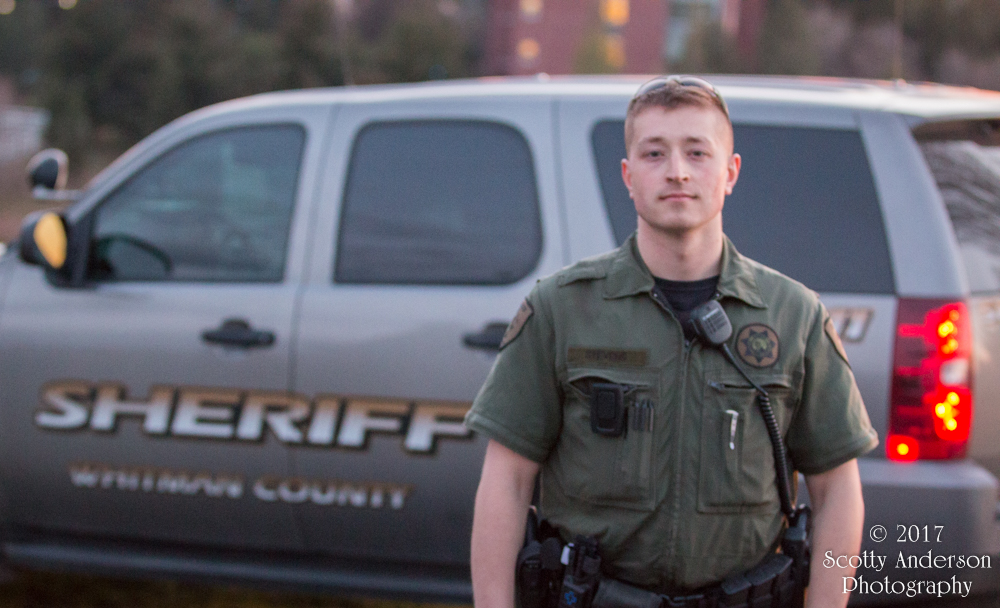
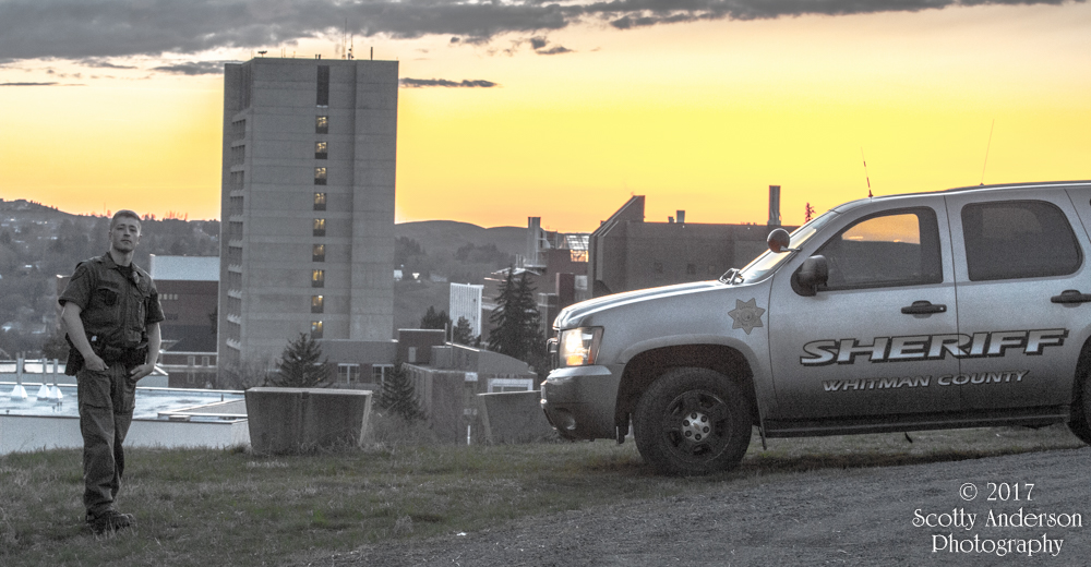
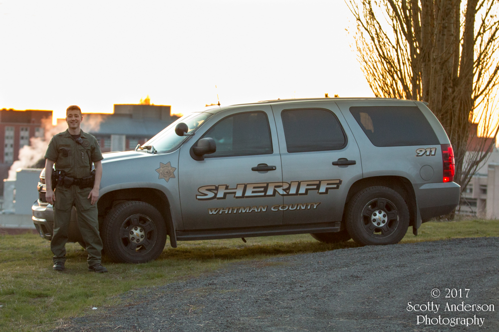
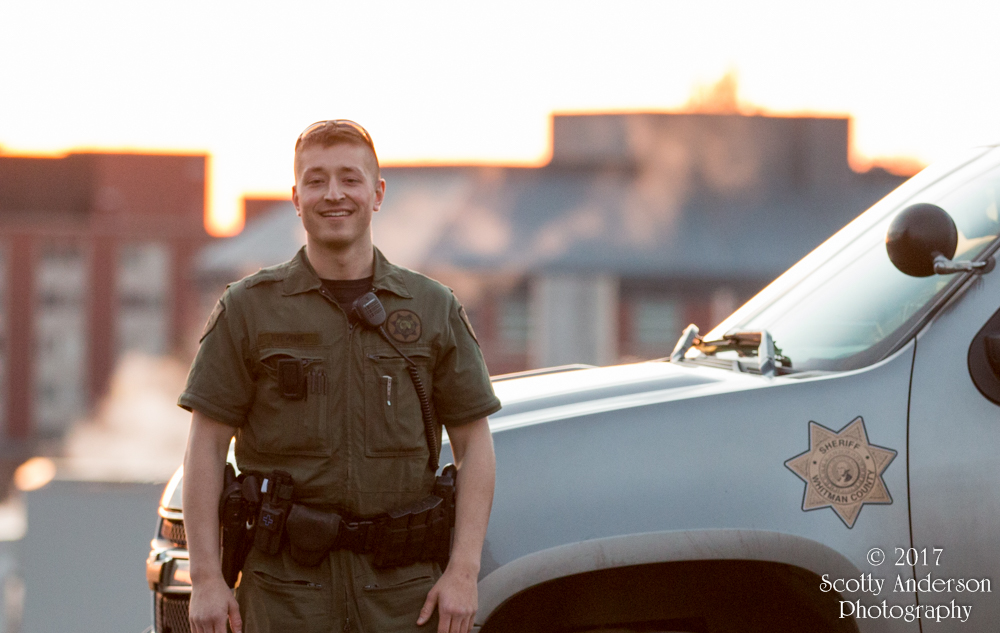
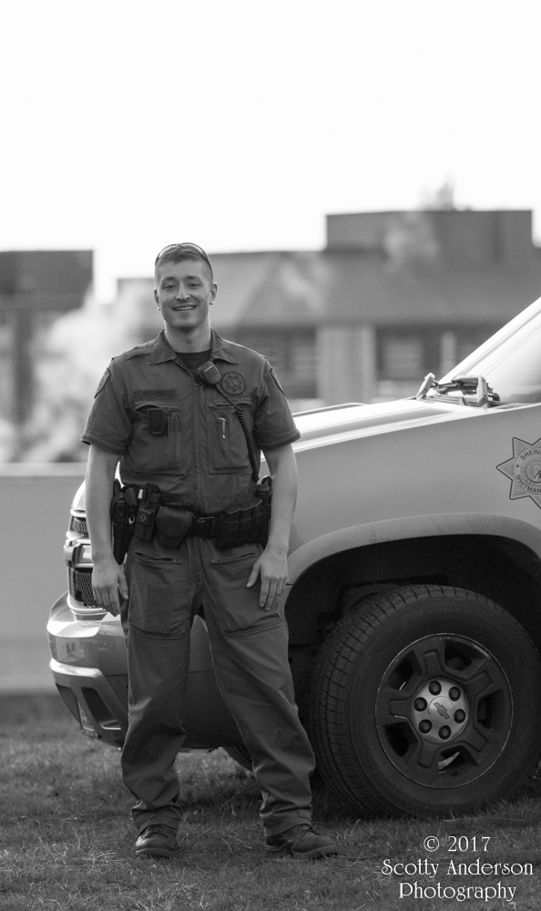
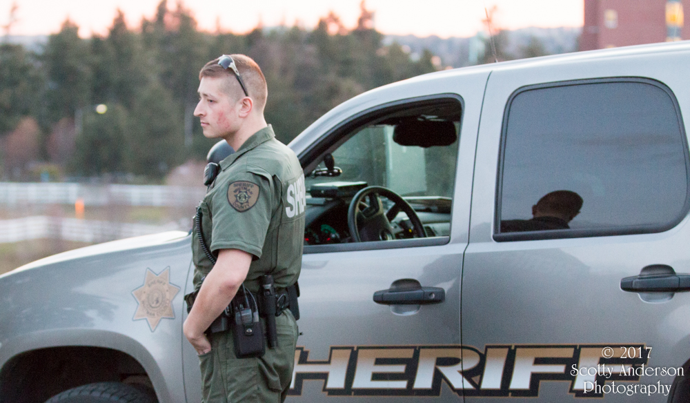
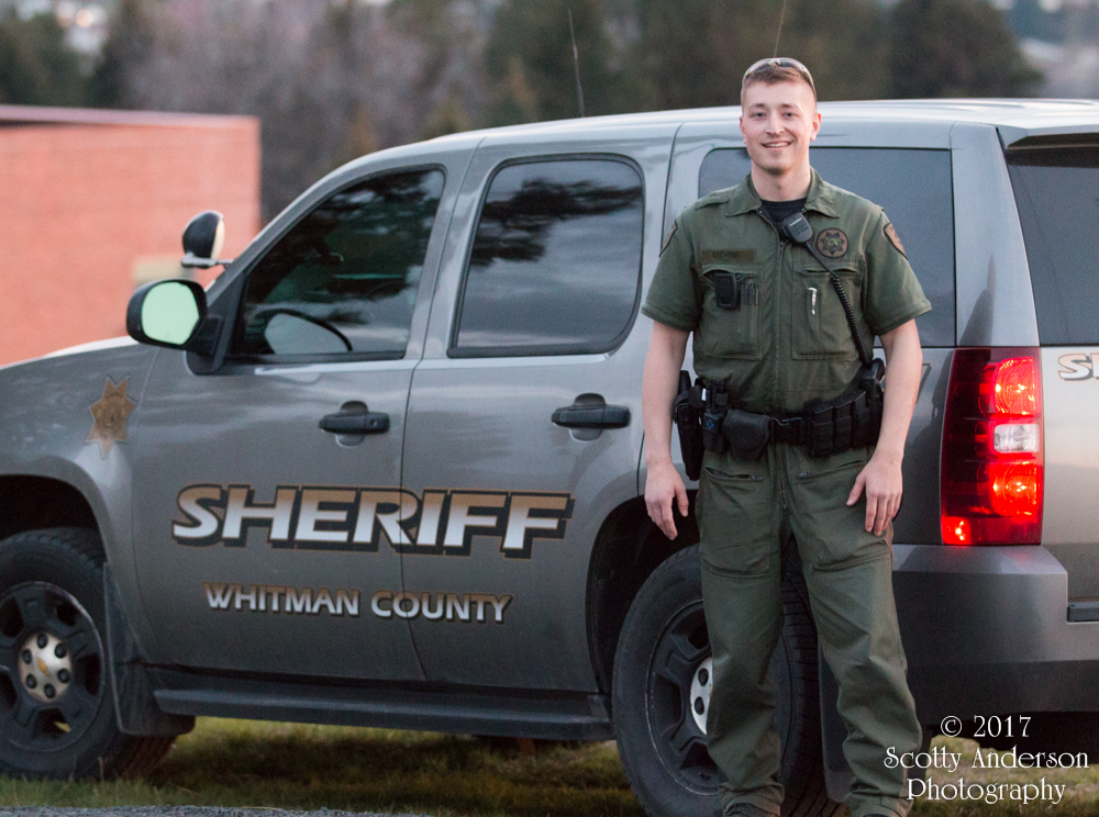
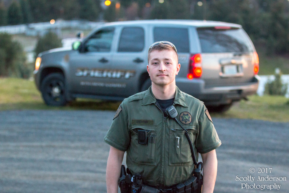
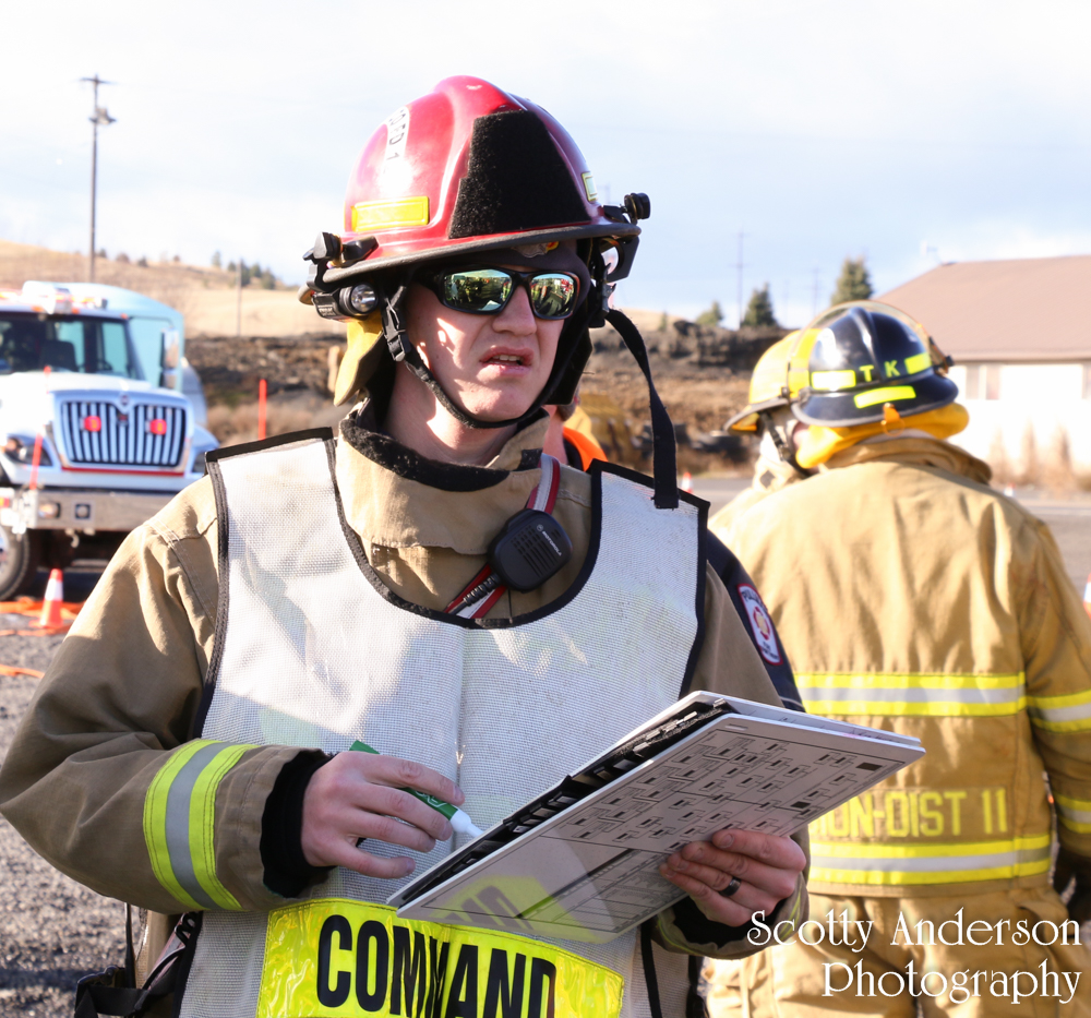
 is inside the overturned bus with the simulated patients.")


.")


 is on scene to assist.")


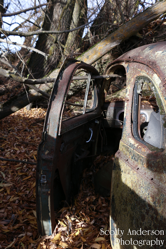


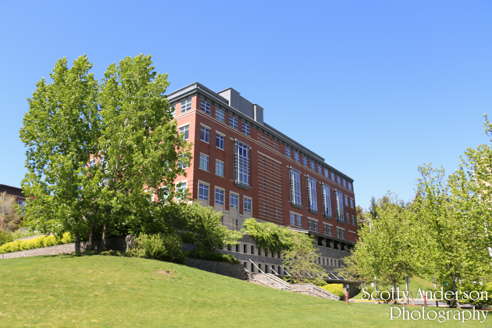
. Taken from Stadium Way near the driveway to the CUE's parking garage.")

 and Fulmer Hall. On the left is Shock Physics.")


. Straight ahead is the entrance to Neill Hall. Neill Hall was dedicated in 1957 as a residence hall and converted to the Math building in 1991. To the left is the East wing of Stimson Hall.")


")


 Education Addition, Cleveland Hall, and Owen Science Library.")


 Owen Science Library, Stimson Hall, Waller Hall, and Webster Physical Science.")
.")


 along with a center complex. At one time there was a dining center, computer lab, convenience store, study lounges, recreation areas, and more. The Complex can hold around 900 students. The North and South towers were completed in 1966. The East tower was completed in 1969.")
 along with a center complex. At one time there was a dining center, computer lab, convenience store, study lounges, recreation areas, and more. The Complex can hold around 900 students. The North and South towers were completed in 1966. The East tower was completed in 1969.")


 is on the right side of the photo. Dana Hall is in the center of the photo taken from the College Ave and Spokane Street intersection. The ETRL was completed in 1997 and Dana Hall was completed in 1948.")
 is visible on the right side of the photo. This was once the main entrance to campus.")


 TV News Anchor.")


 has been converted into windows.")


. The old Bookie building and a portion of Kimbrough Hall is visible. The Bookie was built in 1954 and served as a bookstore until 2008 when it moved into the CUB. The front of the building which served as a covered walkway. It was made of bricks and gave a new look to the building has been torn off the building in preparation of the building to be repurposed as another student center. The covered walkway was added to the store during a remodel in the late 90's, if I recall correctly.")

.")


. The building is the student union building. Before a major remodel in 2008 this entrance would have lead into a small convenience store. The building was built in 1952. It once had a parking lot on the east side. It included a radio station, bowling alley, arcade, pool tables, restaurants, a movie theatre, ball rooms, student organization offices, University Recreation offices, ASWSU, and a hotel on the 4th floor. The remodel of 2008 massively changed the building. The interior was gutted to the supports. During construction you could see from one end of the building to the other. The newly remodeled building lost many of the old features but gained new ones.")

 and the Smith Center for Undergraduate Education is visible.")
 and the Smith Center for Undergraduate Education. The walking area between these buildings is known as Troy Lane. It was a well used roadway when the CUB had a parking lot.")


 along with its main entrance. The building is the student union building. The building was built in 1952. It once had a parking lot on the east side. It included a radio station, bowling alley, arcade, pool tables, restaurants, a movie theatre, ball rooms, student organization offices, University Recreation offices, ASWSU, and a hotel on the 4th floor. The remodel of 2008 massively changed the building. The interior was gutted to the supports. During construction you could see from one end of the building to the other. The newly remodeled building lost many of the old features but gained new ones.")


. In the foreground is the Fine Arts building. In the distance is Bustad. According to the WSU Master Plan Stadium Way would be realigned and empty onto Grimes Way without such a tight corner. The roadway from that intersection north would be closed to vehicles. It would be turned into a pedestrian area much like Library Road and the Terrell Mall. The planter median of the roadway was put in place in the last decade to slightly narrow the lanes of traffic. This was to help slow down the traffic that travels along the portion of Stadium Way.")

 on the left and Bustad on the right.")

